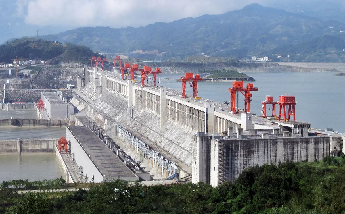
The Three Gorges Dam Project stands as a symbol of ambition and ingenuity, a testament to mankind’s ability to reshape nature. Its grandeur and scale captivate the imagination, but behind this awe-inspiring feat of engineering lies a crucial technological force that has played an indispensable role in its success – Geographic Information Systems (GIS). This powerful tool has revolutionized the way the dam is planned, constructed, and managed, enabling its expansion in ways unimaginable before.
GIS: The Driving Force Behind Three Gorges Dam Expansion
At the heart of the Three Gorges Dam’s remarkable expansion lies GIS, a technology that has been integral in overcoming the complex challenges posed by this colossal project. By harnessing the power of GIS, engineers and planners have been able to analyze vast amounts of geospatial data, making informed decisions that optimize the dam’s expansion plans.
GIS serves as the guiding light, illuminating the path to success. It provides a comprehensive and holistic view of the project area, assimilating geographical, topographical, and geological data, as well as socio-economic and environmental factors. With this wealth of information at their fingertips, project stakeholders can effectively navigate the myriad complexities involved in the expansion process.

One of the key advantages of GIS in the Three Gorges Dam project is its ability to integrate various data sources. By combining satellite imagery, aerial photographs, and ground surveys, GIS creates a seamless and accurate representation of the project area. This integrated approach ensures that all relevant information is taken into account, allowing engineers and planners to make well-informed decisions.
Furthermore, GIS enables the analysis of terrain characteristics, such as slope, elevation, and soil composition. This information is crucial for determining the optimal location and design of the dam’s expansion. By identifying areas with stable ground conditions and suitable topography, engineers can minimize the risks associated with construction and ensure the long-term stability of the dam.
In addition to its geospatial capabilities, GIS also plays a vital role in assessing the socio-economic and environmental impacts of the expansion. Through the integration of demographic data, land use patterns, and environmental indicators, GIS helps project stakeholders understand the potential consequences of the dam’s expansion on local communities and ecosystems.
With GIS, engineers and planners can identify areas that may be affected by the dam’s construction, such as displacement of communities or changes in water quality. This knowledge allows for the implementation of mitigation measures to minimize negative impacts and maximize the project’s benefits. By considering socio-economic and environmental factors, the expansion of the Three Gorges Dam can be carried out in a sustainable and responsible manner.
Moreover, GIS facilitates effective communication and collaboration among project stakeholders. By providing a visual representation of the project area and its various components, GIS allows for better understanding and decision-making. Engineers, planners, environmentalists, and local communities can all contribute their expertise and perspectives, leading to more inclusive and comprehensive expansion plans.
In conclusion, GIS is the driving force behind the remarkable expansion of the Three Gorges Dam. Its ability to analyze geospatial data, integrate diverse information sources, and assess socio-economic and environmental impacts has been instrumental in overcoming the complex challenges of this colossal project. With GIS as their guiding light, engineers and planners can navigate the intricacies of the expansion process and ensure the long-term success and sustainability of the dam.
Enhancing the Potential of A Project with GIS
Not only does GIS play a fundamental role in the expansion, but its impact extends to the existing operation of the dam as well. By integrating real-time data from various sources, such as weather monitoring systems and river gauges, GIS empowers dam administrators to make informed decisions that optimize power generation and flood control. The ability to assess and respond to changing conditions ensures that the dam operates at its full potential for the benefit of all.
Moreover, GIS aids in the proactive management of the dam’s ecological impact. By accurately mapping the project site and its surroundings, GIS enables scientists and environmentalists to study the ecosystem’s changes over time. Through the data-driven insights provided by GIS, researchers can identify potential environmental concerns and develop strategies to mitigate negative impacts, ensuring a harmonious coexistence between the dam and its surroundings.

GIS: An Essential Tool for Three Gorges Dam Project
The implementation of GIS has transformed the construction process of the Three Gorges Dam, streamlining workflow and optimizing resource allocation. With GIS, project managers can precisely track the allocation of materials, manpower, and machinery, enhancing efficiency and minimizing costs. Time and resources that were previously wasted on redundant activities can now be redirected towards critical tasks, accelerating the project’s progress.
Furthermore, GIS plays a pivotal role in risk assessment and safety management. By integrating data on geological instability, seismic activity, and other potential hazards, GIS enables engineers to pre-emptively identify areas of concern and implement mitigation measures. This proactive approach to risk management safeguards both the value of the project and the safety of the workers involved.
Streamlining Expansion at Three Gorges Dam
The continuous expansion of the Three Gorges Dam project demands precision and foresight. GIS acts as a guardian, ensuring that every decision and action undertaken during the expansion adheres to the project’s goals and objectives. By integrating data from various sources and using sophisticated geospatial analysis tools, GIS generates invaluable insights that aid in the ongoing expansion efforts.
The utilization of GIS facilitates effective coordination between multiple stakeholders involved in the expansion, enabling seamless collaboration and efficient communication. By providing a common platform for sharing spatial data and progress updates, GIS acts as a unifying force, keeping everyone connected and informed. This cohesion not only enhances productivity but also fosters a spirit of teamwork and collective responsibility.
The Future: A GIS-Powered Expansion
As the Three Gorges Dam continues to evolve and expand, GIS will remain at its core, empowering every decision and guiding every action. The potential of this remarkable technology is boundless, with continuous advancements allowing for even greater capabilities in the future.
From analyzing complex data to improving operational efficiency to ensuring environmental sustainability, GIS has proven itself to be an indispensable tool in the success of the Three Gorges Dam Project. It inspires us to push the boundaries of what is possible, captivating us with its limitless potential. The empowering expansion of the Three Gorges Dam truly exemplifies the vital role of GIS in shaping our world.


